
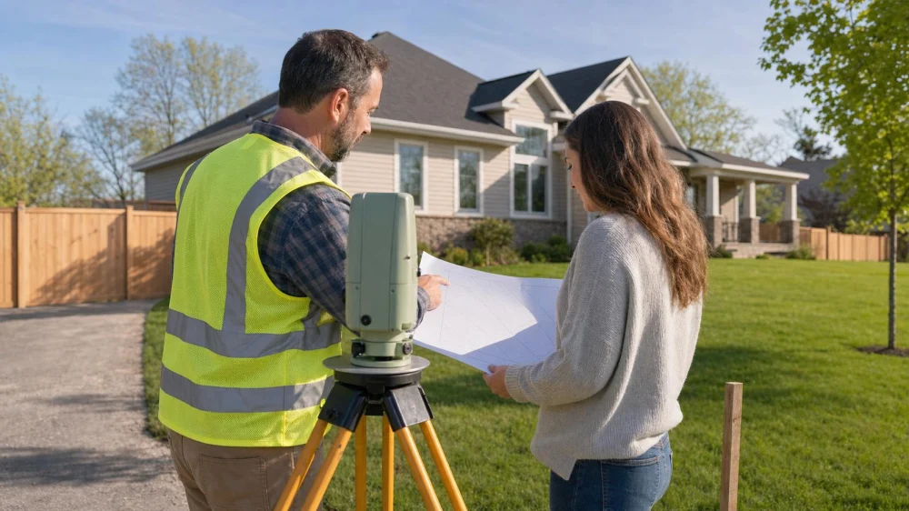
Property Boundary Checks Before Buying a Home
On this page
Quick answer
Before buying a home, compare the deed description, recorded plat, title documents, and any available survey with what you see on the land. Do not treat fences, lawns, online parcel maps, or a seller’s recollection as proof of the legal boundary. Investigate encroachments and access rights early, and use a licensed surveyor or real estate attorney when the location or rights remain unclear.
A property boundary is the legally described limit of a parcel, not necessarily the line where a fence, driveway, hedge, or mowing pattern appears. Confirming that limit helps a buyer understand what is included, who may use part of the land, and whether planned improvements are likely to fit.

Why property boundaries matter
A boundary issue can affect everyday use of a home. A driveway may cross another parcel, a shed may extend over a lot line, or a utility easement may limit where a future pool or addition can go. Even a small discrepancy can complicate maintenance, financing, insurance, resale, or relations with neighbors.
Boundary due diligence is best for buyers who need certainty about acreage, parking, access, detached structures, waterfront or rural land, or future construction. It is not a substitute for title review, zoning research, a home inspection, or legal advice; each answers a different question.

787 Seventh Avenue / 787 seventh avenue new york
New YorkNew York CountyNew York
787 7th Ave, New York, NY 10019, USA
Records to review
Ask the seller or listing agent whether a prior survey exists and whether the property has changed since it was prepared. Additions, new fences, replaced driveways, lot splits, and neighboring construction may reduce the usefulness of an older survey.
- Deed: identifies the conveyed parcel and contains or refers to its legal description.
- Recorded plat or subdivision map: may show lot dimensions, streets, common areas, and recorded easements.
- Prior survey: may show measured corners, improvements, and visible encroachments as of its survey date.
- Title commitment or preliminary report: lists recorded exceptions, easements, restrictions, and documents for further review.
- Tax assessor or GIS map: is useful for orientation and parcel identification, but usually warns that it is not a legal survey.
- Permits and site plans: may help explain additions or structures, but approval does not automatically prove ownership or boundary location.
Check that parcel numbers, owner names, legal descriptions, street references, and lot dimensions are consistent across records. A mismatch may be a clerical issue, but it should be resolved before the buyer relies on it.
Walk the property carefully
Visit in daylight and view the site from lawful access points. Look for survey pins only if they are visible; do not dig, move markers, enter neighboring land, or assume that a found stake is current or official.
Compare visible improvements with the documents. Note fences that change direction, shared or unusually narrow driveways, retaining walls, sheds close to an apparent line, roof overhangs, gates used by neighbors, utility equipment, drainage channels, paths, and landscaping maintained by someone else. Ask neutral, specific questions about how each area is used.
Photograph observations for your own transaction file without presenting them as measurements. A smartphone location dot or consumer measuring app does not establish a legal boundary.
Understand survey options
A licensed land surveyor researches records, measures the site, evaluates evidence, and prepares work under state standards. The appropriate survey depends on the property and the question. A basic boundary survey, mortgage-related product, improvement-location survey, ALTA/NSPS survey, topographic survey, and construction staking serve different purposes.
When requesting a quote, explain whether you need corners located, visible improvements shown, easements plotted, acreage verified, or a planned project evaluated. Ask what the final deliverable includes, whether monuments will be set, the expected timing, and what records the surveyor needs.
A prior survey may be helpful but not sufficient. A surveyor, title professional, lender, or attorney can explain whether it can be relied on for the present transaction and intended use.
Check easements and access
An easement is a right to use land for a stated purpose, such as utilities, drainage, shared access, or a private road. It does not always prevent ownership, but it may limit construction or require access to remain open. Read the recorded document rather than relying only on a line drawn on a map.
Confirm that the home has legal, practical access to a public road. For a shared or private road, review who can use it, who maintains it, how costs are divided, and whether a lender or insurer has additional requirements. Also ask about unrecorded arrangements claimed by the seller or neighbors; informal practice may not provide the rights a buyer expects.
If a fence, driveway, wall, building, or regular use crosses an apparent line, do not negotiate a casual fix on your own. A surveyor can locate the condition, while a real estate attorney and title professional can evaluate ownership, easement, encroachment, and insurance implications.
Buyer checklist
- State what you need to know: exact acreage, corners, access, improvements, or room for a future project.
- Request the deed, recorded plat, prior surveys, and relevant title documents.
- Check dates and ask what physical changes occurred after any prior survey.
- Walk the property and note fences, driveways, structures, paths, utilities, and drainage features.
- Compare visible conditions with the records without treating online maps as proof.
- Ask a licensed surveyor which product fits the property and intended use.
- Have title and legal professionals review easements, access rights, restrictions, and discrepancies.
- Resolve material issues within the contract’s deadlines and in writing.
- Keep the final survey and recorded documents with the closing file.
Important notes and professional triggers
Use professional help when records conflict, corners cannot be identified, acreage is important to value, a structure appears close to a line, access crosses private land, the parcel is irregular or rural, water boundaries are involved, or future construction depends on available space. Boundary and property law varies by state.
Do not remove a fence, move a marker, confront a neighbor, or promise a boundary solution before qualified review. A physical occupation may raise issues beyond simple measurement, and only an appropriate legal professional can advise on legal rights or remedies.
This article is general real estate education for United States buyers. It does not establish a boundary, interpret a deed, guarantee insurability, or replace advice from a licensed surveyor, real estate attorney, title professional, lender, or local land-use authority.
Frequently asked questions
Is the fence the legal property line?
Not necessarily. A fence may have been placed inside, outside, or across the boundary for practical reasons. Compare it with reliable survey evidence and recorded documents before treating it as the legal line.
Can I rely on a county parcel map?
Use it to locate and research a parcel, not to establish a precise boundary. Many assessor and GIS systems state that their lines are approximate and intended for tax or planning reference.
Who normally pays for a survey?
Practices vary by market, contract, lender, and negotiation. Ask the real estate professionals involved what is customary, then make the contract clear about responsibility, timing, and the required survey product.
What happens if a shed crosses the line?
First confirm the condition with appropriate survey work. Then have the title company and a real estate attorney evaluate available options, contract rights, lender concerns, and any written agreement or correction. Do not assume the structure can simply remain or be moved.
Does title insurance replace a survey?
No. A survey locates and depicts relevant physical and boundary evidence; title insurance addresses covered title risks under its policy and exceptions. Ask the title professional how survey matters are treated in the proposed coverage.
Sources and evidence notes
This guide reflects common United States real estate due-diligence practice: distinguish assessment maps from surveys, compare recorded records with visible occupation, identify access and easements, and refer measurement and legal questions to licensed professionals. The deed, recorded documents, current survey work, purchase contract, title materials, and applicable state and local law control a specific transaction.
Next steps
Before the inspection period ends, gather the deed, plat, title commitment, and any prior survey. Walk the lot with your intended use in mind and list every uncertain line, crossing, or access point. Send those questions to the appropriate survey, title, legal, and real estate professionals early enough to investigate and make a contract decision.





 Island Select Realty5.0 (1 reviews)
 AG CORE REALTY0.0 (0 reviews)
 Andrew Fernandez - RE/MAX Voyage Realty0.0 (0 reviews)
 Howard Hanna | Coach Realtors - Stony Brook5.0 (1 reviews)
 Home Sweet Home Realty Group, Llc.0.0 (0 reviews)
 LSL Advisors4.0 (5 reviews)
 Understanding the Benefits of Energy-Efficient Upgrades for Homeowners in the US
 Understanding the Impact of Inflation on Property Values
 Tips for Investing in Multi-Unit Residential Properties
 How to Navigate Real Estate Contracts Without Errors: A Complete Guide
 How to Make Your Home More Attractive to International Buyers
 How to Sell Your Home With Minimal Stress and Maximum Profit